
Connecticut City Neighborhood Profiles
Interactive Visualizations
Related Data
Connecticut Town Data Viewer
DataHaven has maintained neighborhood and community profiles and maps for over 30 years. The Connecticut Town Data Viewer includes estimates for all 169 towns Connecticut towns, COG regions, and the state as a whole on topics such as quality of life, financial security, neighborhood assets, health, income, housing, and demographics.
View the 2024 Connecticut Town Data Viewer by clicking here.
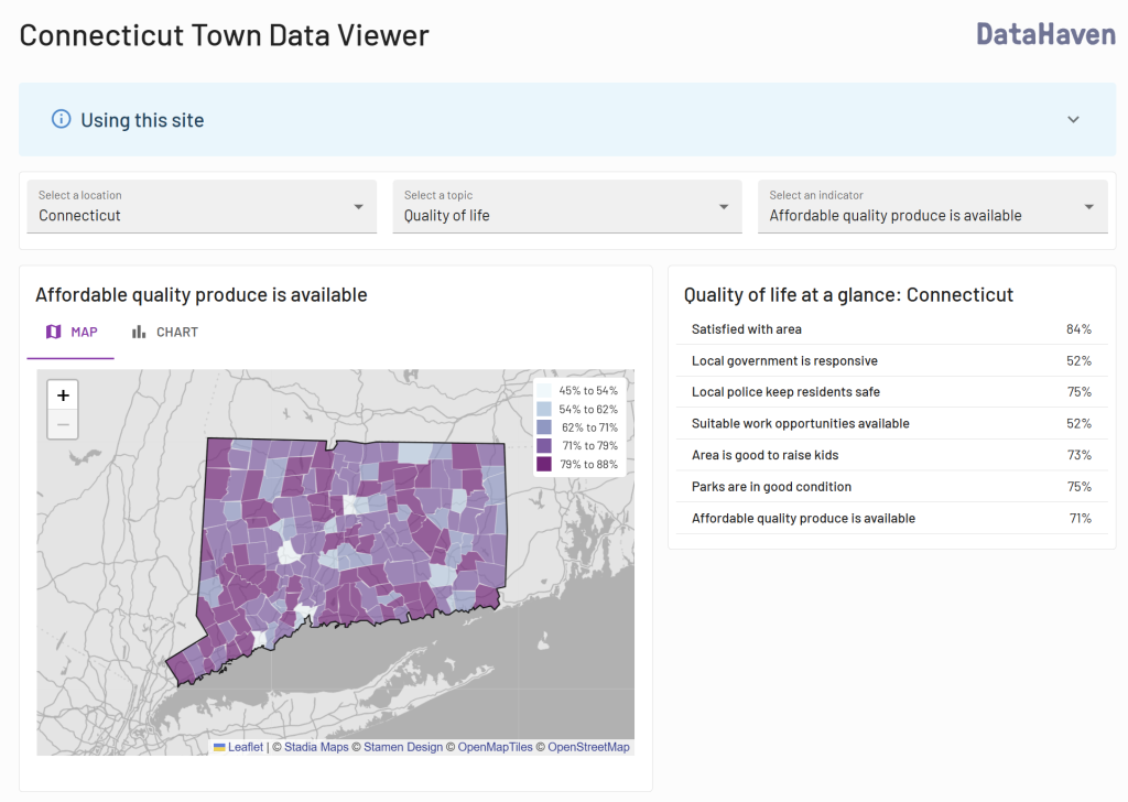
Using the Viewer
Click the map or use the dropdown menus to select your town and topic of interest. After viewing the visualization, click on the “X” in the top right to return to this page.
Links to download the raw data are embedded within the visualization itself (see links at bottom). Please contact us if you have any issues accessing these data files.
Other relevant resources
- DataHaven publishes data profiles for neighborhoods within Connecticut cities, and for State Senate and House Districts.
- A DataHaven report, 2020 Census Data: Demographic Change in Connecticut Town and City Neighborhoods, contains maps and analyses of changes since the 2010 Census, based on local results from the 2020 Census that were first released in August 2021.
- DataHaven’s Connecticut Town Equity Reports contain local maps for all 169 towns in the state.
- DataHaven publishes analyses of the local-level impacts of policies such as a proposed Child Tax Credit, cuts to healthcare and food assistance, and tax effects of legislation, typically at the town and/or legislative district level. These are posted on the main reports page of our website.
More information
Please contact us with any questions. Data for other Connecticut communities, towns, and areas are posted on our community profile page, in our Town Equity Reports, and elsewhere on this website.
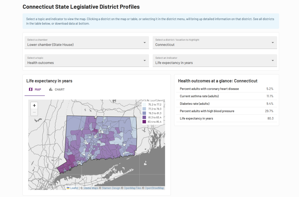
Connecticut State Legislative District Profiles
About the Profiles
DataHaven has maintained neighborhood and community profiles and maps for over 30 years. The estimates in our Connecticut State Legislative District Profiles are based on Connecticut State House and Senate districts. Unlike many other online maps, the data visualization technology we use is highly responsive across mobile devices.
2024 Legislative District Profiles
Begin by selecting your legislative chamber (House or Senate). Click the map or use the dropdown menus to select your legislative district. Click “map” or “chart” to toggle between the interactive charts and statewide map. After viewing the visualization, click on the “X” in the top right to return to this page.
Links to download the raw data are embedded within the visualization itself (see links at bottom). Please contact us if you have any issues accessing these data files.
Other relevant resources
- To access town-level data for the entire state, we recommend accessing DataHaven’s Connecticut Town Data Viewer.
- DataHaven publishes data profiles for neighborhoods within Connecticut cities.
- A DataHaven report, 2020 Census Data: Demographic Change in Connecticut Town and City Neighborhoods, contains maps and analyses of changes since the 2010 Census, based on local results from the 2020 Census that were first released in August 2021.
- DataHaven’s Connecticut Town Equity Reports contain local maps for all 169 towns in the state.
- DataHaven publishes analyses of the local-level impacts of policies such as a proposed Child Tax Credit, cuts to healthcare and food assistance, and tax effects of legislation, typically at the town and/or legislative district level. These are posted on the main reports page of our website.
Previous editions
View the 2020 edition of the profiles by clicking here.
View the 2019 edition of the profiles by clicking here.
More information
Please contact us with any questions. Data for other Connecticut communities, towns, and areas are posted on our community profile page, in our Town Equity Reports, and elsewhere on this website.
New Haven Neighborhood Profile CSV 2022 5Y
This is a raw dataset with neighborhood profile data developed by DataHaven using the 2022 5-year American Community Survey, CDC PLACES (2023 data release), and USALEEP data calculated by DataHaven for individual New Haven neighborhoods.
For our main Connecticut City Neighborhood Profiles page, which includes data visualizations of datasets about geographic areas such as towns, city neighborhoods, and legislative districts throughout Connecticut, click here or go to our Data Dashboard, select the visualization of interest, and use the drop down menus to filter for city and indicators. Data sources are described on that page; more current versions of the dataset may be included in this version of the file.
Bridgeport Neighborhood Profile CSV 2022 5Y
This is a raw dataset with neighborhood profile data developed by DataHaven using the 2022 5-year American Community Survey, CDC PLACES (2023 data release), and USALEEP data calculated by DataHaven for individual Bridgeport neighborhoods.
For our main Connecticut City Neighborhood Profiles page, which includes data visualizations of datasets about geographic areas such as towns, city neighborhoods, and legislative districts throughout Connecticut, click here or go to our Data Dashboard, select the visualization of interest, and use the drop down menus to filter for city and indicators. Data sources are described on that page; more current versions of the dataset may be included in this version of the file.