Rising Neighborhood Income Inequality in Connecticut
In last 35 years, a drop in middle-income neighborhoods
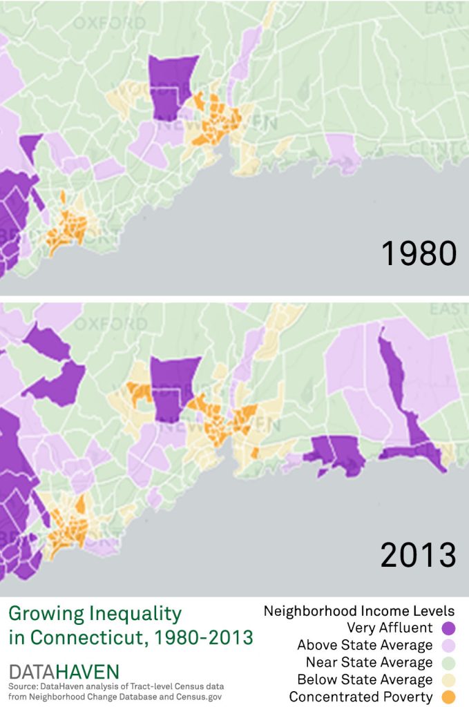
From 1980 to 2013, the percentage of Connecticut residents living in neighborhoods of concentrated wealth or poverty grew by 30 percent, according to a new analysis from DataHaven. [Note: The interactive map related to this article is no longer active].
Meanwhile, the percentage of residents living in middle-income neighborhoods shrunk 7 percent.
These trends show that income inequality is a chronic issue — and that the polarization of Connecticut neighborhoods is growing. Studies show that this concentration of wealth and poverty causes several negative outcomes. Among them are poor health and high crime in areas of extreme poverty, and the concentration of regional resources in very affluent neighborhoods for richer residents.
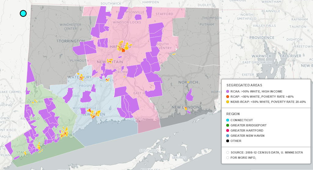
Additionally, our recently published analysis that compared Connecticut to a national study of racially concentrated affluence showed that Connecticut faces racial segregation along income lines that in many ways surpass those of other large metropolitan areas.
So what exactly has changed in the last 35 years?
- In 2013, 40 percent of Connecticut residents lived in neighborhoods with an average family income near the state average, a sharp drop from 56 percent of residents in 1980. This represents a 28 percent decrease since 1980.
- In 2013, 25 percent of Connecticut’s total population lived in extreme-income neighborhoods, those at one or the other end of the income scale, up from 19 percent in 1980 — a 30 percent increase.
- This included 10 percent of the population who lived in very affluent neighborhoods in 2013 — a 47 percent increase from 1980.
- And 15 percent who lived in very poor neighborhoods in 2013 — a 20 percent increase since 1980.
On top of this, the share of residents who are poor and live in an area of concentrated poverty — what we call “double jeopardy” — grew 66 percent since 1980, to 4 percent of all Connecticut residents. This is the group that experienced the fastest rate of growth.
HOW WE CATEGORIZED NEIGHBORHOODS
DataHaven categorized every census tract in Connecticut based on average family income and poverty rate — and we did it for 1980, 1990, 2000 and 2013. A census tract has about 4,000 people, and aims to align with neighborhood boundaries; we used a special database that adjusts for the Census Bureau’s frequent changes to these small geographic boundaries over time. We borrowed the categories below from a recent Stanford University report (Reardon and Bischoff, 2011, Growth in the Residential Segregation of Families by Income, 1970-2009):
- Very affluent: A neighborhood (defined as a census tract) in which the average family income is at least 1.5 times the statewide average.
- Above State Average A neighborhood in which the average family income is between 1.25 and 1.5 times the statewide average.
- Near State Average: A neighborhood in which the average family income is between 0.8 and 1.25 times the statewide average.
- Below State Average: A neighborhood in which the average family income is under 0.8 times the statewide average, but less than 20 percent of the population lives in poverty.
- Concentrated Poverty: A neighborhood in which at least 20 percent of the population lives in poverty.
GREATER HARTFORD TOPS REGIONAL INEQUALITY GROWTH
Over this period every region has experienced these expanding inequality trends. Greater Hartford (Hartford, Tolland and Middlesex counties) had the largest growth of residents living in extreme-income neighborhoods. From 1980 to 2013, the percentage of people living in very affluent or very poor neighborhoods grew by 55 percent. In both Greater New Haven (New Haven County) and Greater Bridgeport (Fairfield County), the percentage grew by 21 percent.
The degree of concentrated affluence or poverty varies between regions. For example, a remarkably high share of Greater Bridgeport lives in extreme-income neighborhoods: 42 percent were in these extreme-income neighborhoods in 2013, compared to 21 percent in Greater Hartford and 22 percent in Greater New Haven.
Only 9 percent of residents in all other Connecticut towns (Litchfield, New London and Windham counties) live in either very rich or very poor neighborhoods. But in these areas, as well, this share has increased significantly — by 51 percent since 1980.
WHERE EXTREME-INCOME NEIGHBORHOODS ARE LOCATED
Many neighborhoods were middle-income neighborhoods in 1980, but became very affluent by 2013. These areas are scattered around the state, but are most numerous in Greater Bridgeport — along the coast and bordering New York — and northwest of Hartford. There are also small pockets of newly affluent neighborhoods southwest of Hartford, east of New Haven and along the northern New York-Connecticut border.
Since 1980, concentrated poverty neighborhoods have mostly been clustered together, in and surrounding urban centers. By 2013, many previously middle-income urban and suburban neighborhoods had transitioned to concentrated poverty areas. Consequently, from 1980 to 2013 the contiguous poor district in each city expanded – most notably in Hartford, New Britain, Waterbury, New Haven and Bridgeport. A few concentrated poverty neighborhoods in isolated rural pockets around the state also grew from 1980 to 2013.
According to the 2013 Greater New Haven Community Index, while the potential responses to these changes are widely debated at all levels of society, it is clear that Connecticut has been experiencing faster polarization of neighborhoods by income level than many other regions have. If Connecticut had managed to preserve its middle-income neighborhoods over the past 30 years, far fewer of our children today would be growing up in disadvantaged neighborhoods.
Note: Readers may wish to visit DataHaven’s neighborhood and town profiles to examine detailed indicators on the differences across and within Connecticut cities and towns.
Mary Buchanan is the Project Manager and Mark Abraham is the Executive Director of DataHaven, a formal partner of the National Neighborhood Indicators Partnership with a 25-year history of public service to Greater New Haven and Connecticut. DataHaven’s mission is to improve quality of life by compiling, sharing and interpreting public data for effective decision making. This analysis is based on information from the Neighborhood Change Database (NCDB) 2010 created by GeoLytics and the Urban Institute with support from the Rockefeller Foundation, 2012.
Note: This report originally appeared on TrendCT (CT Mirror) on June 17, 2015.

